Located in Westfield, NC, this exceptionally nice generational property offers a rare opportunity to own a large, versatile tract with endless potential. The property features substantial frontage along Tom Mix Rd, with land situated on both sides of the roadway.
The southern portion of the tract encompasses just over 34 acres, gently sloping east from the roadside down to a scenic stream that forms the eastern boundary. Several excellent homesite locations sit along the road frontage, currently surrounded by mature white pine. As the land descends toward the creek, the landscape transitions into beautiful mature hardwood timber, creating a peaceful, park-like setting with the potential for long-range views.
The northern portion consists of approximately 60 acres of expansive woodland, highlighted by multiple ridgelines that overlook the creek bottom along the northern boundary. This section also features pockets of mature white pine, Virginia pine, and mixed hardwoods. Numerous potential homesites are positioned along the road frontage, offering privacy and attractive building opportunities.
With significant road frontage and acreage on both sides of Tom Mix Rd, this tract provides excellent flexibility for a private estate, recreational retreat, or future investment opportunity.
<hr />
<em><strong>Details</strong></em>
<ul>
<li>95+/- AC</li>
<li>Westfield NC</li>
<li><span id="ctl00_PageHeader1_PinLabel" class="h5 bold-default">PIN # </span><span id="ctl00_PageHeader1_PinLabelInfo" class="h5">6010-35-6051</span></li>
<li>Substantial frontage on Tom Mix Rd</li>
<li>Rolling topography</li>
<li>Excellent wildlife habitat</li>
<li>Power currently to front of the property</li>
<li>Mixed Timber</li>
<li>Multiple bold streams</li>
<li>Forestry deferment</li>
</ul>
<hr />
<em><strong>Location</strong></em>
<ul>
<li>8 miles west of Danbury NC</li>
<li>16 miles east of Mount Airy NC</li>
<li>28 miles north of Winston Salem NC</li>
<li>42 miles northeast of Greensboro NC</li>
<li>16 miles east of Hwy 52</li>
</ul>
<hr />
<strong>The information provided by The Clearwater Group concerning real estate listed for sale is believed to be reliable but is not guaranteed and should be independently verified by potential purchasers and their representatives. Information is subject to change, withdrawal, or correction. The Clearwater Group makes no representations or warranties about the property or the accuracy of the information concerning the property including, without limitation: square footage, acreage, zoning, tax information, measurements, and other factors.</strong>
<strong>The information provided concerning the property is not a substitute for inspections, surveys, title searches or other due diligence by potential purchasers. Potential purchasers should perform their own due diligence including legal and financial review before purchasing.</strong>
This tract offers an exceptional blend untouched woodland and privacy located just outside of Danbury NC. The property has substantial frontage along Hanging Rock Forest Rd and offers multiple potential build sites.
<hr />
<em><strong>Details</strong></em>
<ul>
<li>11.9+/- AC - subject to survey</li>
<li>Approx. 2 acres of open land</li>
<li>Power currently to front of the property</li>
<li>Mix of mature timber</li>
<li>Views of the Blue Ridge and Hanging Rock</li>
</ul>
<hr />
<em><strong>Location</strong></em>
<ul>
<li>1 mile to Danbury NC</li>
<li>3 miles to the entrance of Hanging Rock State Park</li>
<li>21 miles north of Winston Salem NC</li>
<li>32 miles northwest of Greensboro NC</li>
</ul>
<hr />
<strong>The information provided by The Clearwater Group concerning real estate listed for sale is believed to be reliable but is not guaranteed and should be independently verified by potential purchasers and their representatives. Information is subject to change, withdrawal, or correction. The Clearwater Group makes no representations or warranties about the property or the accuracy of the information concerning the property including, without limitation: square footage, acreage, zoning, tax information, measurements, and other factors.</strong>
<strong>The information provided concerning the property is not a substitute for inspections, surveys, title searches or other due diligence by potential purchasers. Potential purchasers should perform their own due diligence including legal and financial review before purchasing.</strong>
<!-- Summary --> This tract offers an exceptional blend untouched woodland and privacy located just outside of Danbury NC. The property has substantial frontage along Hanging Rock Forest Rd and offers multiple potential build sites.
<hr />
<em><strong>Details</strong></em>
<ul>
<li>14.5+/- AC - subject to survey</li>
<li>Portion of Pin # 6947-00-4524</li>
<li>Recent soil evaluation</li>
<li>Power currently to front of the property</li>
<li>Public water located at the eastern corner along HRF</li>
<li>Mix of mature timber</li>
<li>Old road called Alpine Dr. cuts through the property</li>
<li>Approx. 12 acres in the Danbury Well Head Protection area.</li>
<li>Partially in the Danbury city limits</li>
<li>Zoning R-3</li>
</ul>
<hr />
<em><strong>Location</strong></em>
<ul>
<li>1 mile to Danbury NC</li>
<li>3 miles to the entrance of Hanging Rock State Park</li>
<li>21 miles north of Winston Salem NC</li>
<li>32 miles northwest of Greensboro NC</li>
</ul>
<hr />
<strong>The information provided by The Clearwater Group concerning real estate listed for sale is believed to be reliable but is not guaranteed and should be independently verified by potential purchasers and their representatives. Information is subject to change, withdrawal, or correction. The Clearwater Group makes no representations or warranties about the property or the accuracy of the information concerning the property including, without limitation: square footage, acreage, zoning, tax information, measurements, and other factors.</strong>
<strong>The information provided concerning the property is not a substitute for inspections, surveys, title searches or other due diligence by potential purchasers. Potential purchasers should perform their own due diligence including legal and financial review before purchasing.</strong>
Offered for the first time, this exceptional 3.9± acre property presents a great opportunity in a highly desirable location between Mount Airy and Pilot Mountain. The property is situated in between Cook School and Jessup Grove Church Rd with substantial frontage on both roads.
This would be an ideal property for a nice homesite or offers opportunity for further subdivision for a savvy home builder.
<hr />
<em><strong>Details</strong></em>
<ul>
<li>3.9+/- acres - subject to survey</li>
<li>Portion of Pin # 5959-00-70-5888</li>
<li>Substantial frontage on Cook School and Jessup Grove Church Rd</li>
<li>Power currently crossing property</li>
<li>Excellent single homesite or ideal for further subdivision</li>
</ul>
<hr />
<em><strong>Location</strong></em>
<ul>
<li>6 miles north of Pilot Mtn NC</li>
<li>7 miles east of Mount Airy NC</li>
<li>4 miles west of Hwy 52</li>
<li>30 miles north of Winston Salem NC</li>
<li>14 miles east of I 77</li>
</ul>
<hr />
<strong>The information provided by The Clearwater Group concerning real estate listed for sale is believed to be reliable but is not guaranteed and should be independently verified by potential purchasers and their representatives. Information is subject to change, withdrawal, or correction. The Clearwater Group makes no representations or warranties about the property or the accuracy of the information concerning the property including, without limitation: square footage, acreage, zoning, tax information, measurements, and other factors.</strong>
<strong>The information provided concerning the property is not a substitute for inspections, surveys, title searches or other due diligence by potential purchasers. Potential purchasers should perform their own due diligence including legal and financial review before purchasing.</strong>
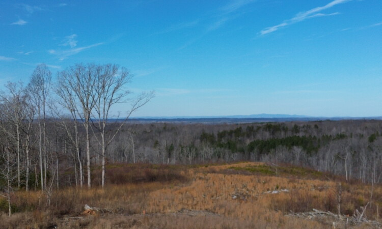
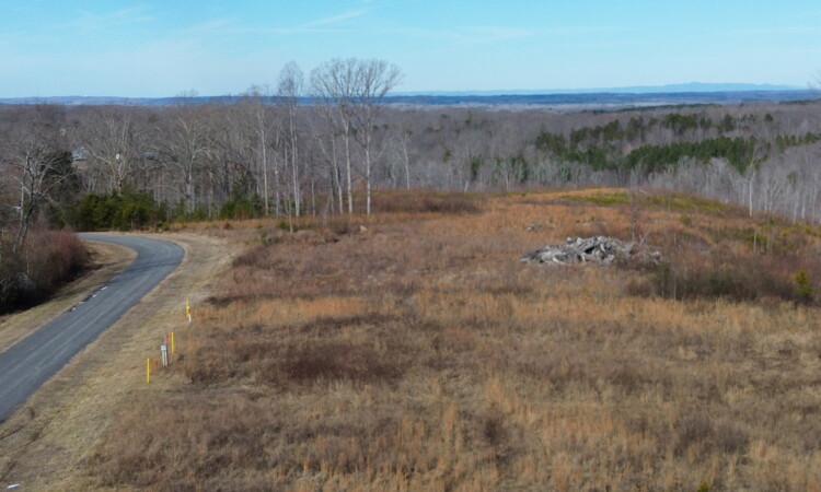
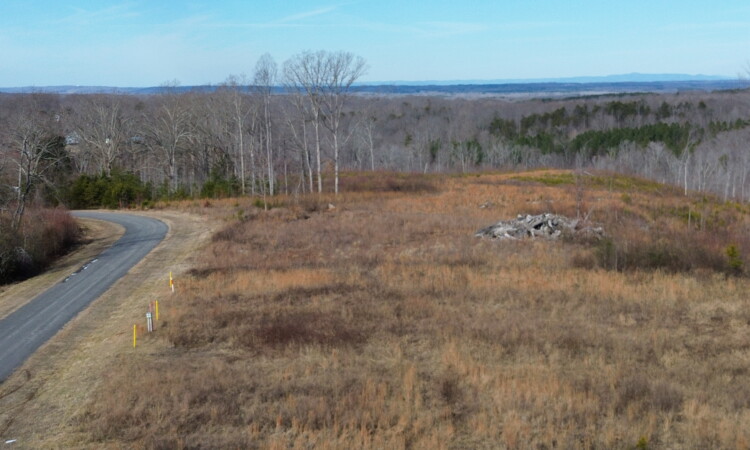
<strong>97± Acres | Between Mount Airy & Pilot Mountain, NC</strong>
Offered for the first time, this exceptional 97± acre generational property presents a rare opportunity to own a sprawling woodland tract in a highly desirable location between Mount Airy and Pilot Mountain.
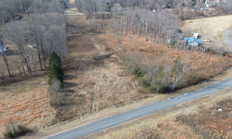
Positioned along the west side of Cook School Road, the property features substantial road frontage and multiple potential homesites. With selective clearing, several building sites could capture impressive long-range views. The land gently rises approximately 20 feet from the road to a scenic plateau overlooking expansive hardwood forest and the creek bottom below — an ideal setting for a private estate.
The tract is comprised predominantly of mature oak and poplar timber, creating a beautiful park-like atmosphere with excellent habitat diversity throughout. As you descend to the creek bottom, you’re welcomed by a peaceful stream bordered by native rhododendron and natural rock ledges, offering a tranquil and picturesque setting.
Adding to the character of the land, an old homestead site remains near the creek, with multiple historic structures that hint at the property’s rich past.
Elevation ranges from approximately 1,240 feet at the creek bank to 1,600 feet at the western ridge, providing varied topography and scenic vantage points.
Whether you’re seeking a premier recreational retreat, investment-grade timberland, or the perfect setting for a private mountain estate, this remarkable tract offers outstanding potential.
<hr />
<em><strong>Details</strong></em>
<ul>
<li>97+/- AC - subject to survey</li>
<li>Portion of Pin # 5959-00-70-5888</li>
<li>Substantial frontage on Cook School Rd</li>
<li>Power currently to front of the property</li>
<li>Mix of mature timber</li>
<li>Bryants Fork Creek traverses through the center of the property</li>
<li>Old homestead and barns located along the creek</li>
<li>Property is under forestry deferment</li>
</ul>
<hr />
<em><strong>Location</strong></em>
<ul>
<li>6 miles north of Pilot Mtn NC</li>
<li>7 miles east of Mount Airy NC</li>
<li>4 miles west of Hwy 52</li>
<li>30 miles north of Winston Salem NC</li>
<li>14 miles east of I 77</li>
</ul>
<hr />
<strong>The information provided by The Clearwater Group concerning real estate listed for sale is believed to be reliable but is not guaranteed and should be independently verified by potential purchasers and their representatives. Information is subject to change, withdrawal, or correction. The Clearwater Group makes no representations or warranties about the property or the accuracy of the information concerning the property including, without limitation: square footage, acreage, zoning, tax information, measurements, and other factors.</strong>
<strong>The information provided concerning the property is not a substitute for inspections, surveys, title searches or other due diligence by potential purchasers. Potential purchasers should perform their own due diligence including legal and financial review before purchasing.</strong>
This is really nice 19.29 acre tract located in Wentworth NC offering privacy and expansive views. The property was recently surveyed and had soil evaluation for a 3bd home.
<hr />
<em><strong>Details</strong></em>
<ul>
<li>19.29+/- acres</li>
<li>Current soil evaluation for 3bd home</li>
<li>Recent survey</li>
<li>Frontage on Bear Branch</li>
<li>Timber harvested approx. 2 yrs ago</li>
<li>Frontage on Valley Level Rd</li>
<li>Sewer line easement on north side of the property.</li>
<li>Long range views of the Blue Ridge Mtn. Range</li>
<li>Rolling topography</li>
<li>Property will be restricted to stick built home only</li>
</ul>
<hr />
<em><strong>Location</strong></em>
<ul>
<li>Located in the Wentworth township</li>
<li>10 miles east of Madison NC</li>
<li>6 miles south of Eden NC</li>
<li>7 miles west of Reidsville NC</li>
<li>10 miles east of Hwy 220 / I 73</li>
</ul>
<hr />
<strong>The information provided by The Clearwater Group concerning real estate listed for sale is believed to be reliable but is not guaranteed and should be independently verified by potential purchasers and their representatives. Information is subject to change, withdrawal, or correction. The Clearwater Group makes no representations or warranties about the property or the accuracy of the information concerning the property including, without limitation: square footage, acreage, zoning, tax information, measurements, and other factors.</strong>
<strong>The information provided concerning the property is not a substitute for inspections, surveys, title searches or other due diligence by potential purchasers. Potential purchasers should perform their own due diligence including legal and financial review before purchasing.</strong>
<table class="d439m44" cellspacing="0" cellpadding="0">
<tbody>
<tr class="d439m24">
<td class="d439m84" colspan="7"><span class="wrapped-field">5.06+/- acres located in Wentworth NC. The property has a nice homesite area along Valley Level Rd with stunning views of the Blue Ridge Mtn Range. The property also has a small stream running with northern boundary. Soil evaluation for a 3bd home and survey completed. Gas line easement runs with eastern boundary.</span></td>
</tr>
</tbody>
</table>
<hr />
<em><strong>Details</strong></em>
<ul>
<li>5.06+/- acres</li>
<li>Current soil evaluation for 3bd home</li>
<li>Recent survey</li>
<li>Timber harvested approx. 2 yrs ago</li>
<li>Frontage on Valley Level Rd</li>
<li>Gas line easement running along eastern boundary</li>
<li>Property will be restricted to stick built home only</li>
</ul>
<hr />
<em><strong>Location</strong></em>
<ul>
<li>Located in the Wentworth township</li>
<li>10 miles east of Madison NC</li>
<li>6 miles south of Eden NC</li>
<li>7 miles west of Reidsville NC</li>
<li>10 miles east of Hwy 220 / I 73</li>
</ul>
<hr />
<strong>The information provided by The Clearwater Group concerning real estate listed for sale is believed to be reliable but is not guaranteed and should be independently verified by potential purchasers and their representatives. Information is subject to change, withdrawal, or correction. The Clearwater Group makes no representations or warranties about the property or the accuracy of the information concerning the property including, without limitation: square footage, acreage, zoning, tax information, measurements, and other factors.</strong>
<strong>The information provided concerning the property is not a substitute for inspections, surveys, title searches or other due diligence by potential purchasers. Potential purchasers should perform their own due diligence including legal and financial review before purchasing.</strong>
<table class="d439m44" cellspacing="0" cellpadding="0">
<tbody>
<tr class="d439m24">
<td class="d439m84" colspan="7"><span class="wrapped-field">6.17+/- acres located in Wentworth NC. The property has a nice homesite area along Valley Level Rd with stunning views of the Blue Ridge Mtn Range. The property also has a small stream running with northern boundary. Soil evaluation for a 3bd home and survey completed. Gas line easement runs with eastern boundary.</span></td>
</tr>
</tbody>
</table>
<hr />
<em><strong>Details</strong></em>
<ul>
<li>6.17+/- acres</li>
<li>Current soil evaluation for 3bd home</li>
<li>Recent survey</li>
<li>Timber harvested approx. 2 yrs ago</li>
<li>Frontage on Valley Level Rd</li>
<li>Gas line easement runs with western boundary</li>
<li>Long range views of the Blue Ridge Mtn. Range</li>
<li>Rolling topography</li>
<li>Restricted to stick built homes only</li>
</ul>
<hr />
<em><strong>Location</strong></em>
<ul>
<li>Located in the Wentworth township</li>
<li>10 miles east of Madison NC</li>
<li>6 miles south of Eden NC</li>
<li>7 miles west of Reidsville NC</li>
<li>10 miles east of Hwy 220 / I 73</li>
</ul>
<hr />
<strong>The information provided by The Clearwater Group concerning real estate listed for sale is believed to be reliable but is not guaranteed and should be independently verified by potential purchasers and their representatives. Information is subject to change, withdrawal, or correction. The Clearwater Group makes no representations or warranties about the property or the accuracy of the information concerning the property including, without limitation: square footage, acreage, zoning, tax information, measurements, and other factors.</strong>
<strong>The information provided concerning the property is not a substitute for inspections, surveys, title searches or other due diligence by potential purchasers. Potential purchasers should perform their own due diligence including legal and financial review before purchasing.</strong>
<table class="d439m44" cellspacing="0" cellpadding="0">
<tbody>
<tr class="d439m24">
<td class="d439m84" colspan="7"><span class="wrapped-field">3.95+/- acres located in Wentworth NC. The property has a nice homesite area along Valley Level Rd. The property Soil evaluation for a 3bd home and survey completed. Gas line easement runs with eastern boundary.</span></td>
</tr>
</tbody>
</table>
<hr />
<em><strong>Details</strong></em>
<ul>
<li>3.95 +/- acres</li>
<li>Current soil evaluation for 3bd home</li>
<li>Recent survey</li>
<li>Timber harvested approx. 2 yrs ago</li>
<li>Frontage on Valley Level Rd</li>
<li>Gas line easement on eastern boundary</li>
<li>Restricted to stick built homes only</li>
<li>Building encroachment</li>
</ul>
<hr />
<em><strong>Location</strong></em>
<ul>
<li>Located in the Wentworth township</li>
<li>10 miles east of Madison NC</li>
<li>6 miles south of Eden NC</li>
<li>7 miles west of Reidsville NC</li>
<li>10 miles east of Hwy 220 / I 73</li>
</ul>
<hr />
<strong>The information provided by The Clearwater Group concerning real estate listed for sale is believed to be reliable but is not guaranteed and should be independently verified by potential purchasers and their representatives. Information is subject to change, withdrawal, or correction. The Clearwater Group makes no representations or warranties about the property or the accuracy of the information concerning the property including, without limitation: square footage, acreage, zoning, tax information, measurements, and other factors.</strong>
<strong>The information provided concerning the property is not a substitute for inspections, surveys, title searches or other due diligence by potential purchasers. Potential purchasers should perform their own due diligence including legal and financial review before purchasing.</strong>