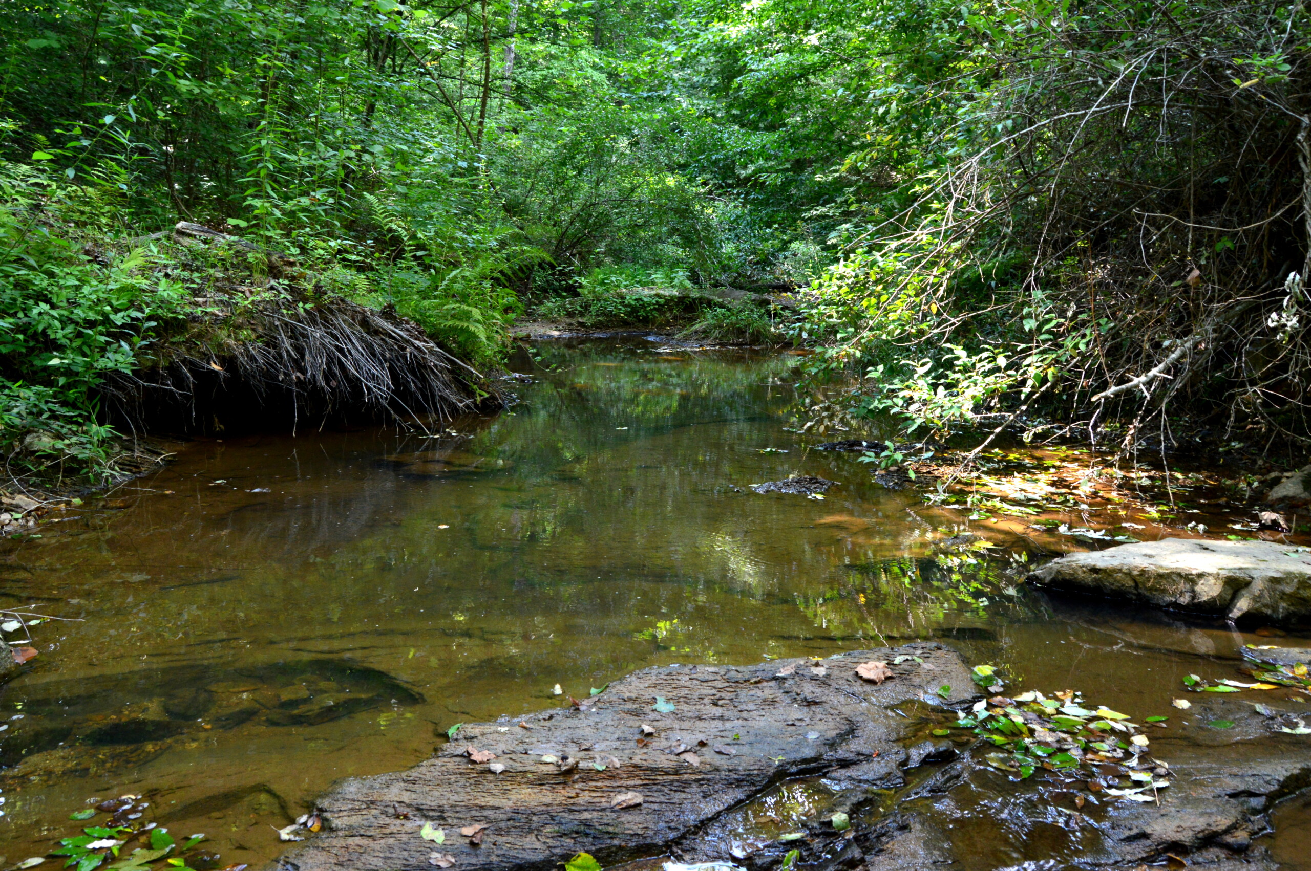
Located just north of Eden NC is this very unique 19 acre tract situated in a very private setting. The property sits on the western side of Martimony Rd and is completed shielded from any outside views. As you enter off of the road there is an established farm road with a unique creek crossing to get you into the core of the tract where you will find a vast 7+/- acre field that offers great views and diverse topography. Along the eastern side of the tract is a nice bluff overlooking Poplar Branch which runs with the entire eastern boundary. This area of the property is immersed in large hardwood timber with a eastern facing slope and unique rock formations.
This tract has been managed for wildlife habitat and makes a great recreational property within its boundaries. The property also would make a great private homestead setting with many options for placement of home and buildings.
<em><strong>The Facts</strong></em>
<ul>
<li>19 +/- Acres - No recent survey</li>
<li>650' +/- of frontage on Matrimony Rd - Gravel / state maintained</li>
<li>940' +/- of frontage along Poplar Branch</li>
<li>7+/- acres of open land</li>
<li>2024 tax bill - $372.05</li>
<li>Mature timber</li>
<li>2 box stands</li>
<li>Previous soil evaluation</li>
<li>Excellent wildlife habitat</li>
<li>Very private setting</li>
<li>Potential old gravesites</li>
</ul>
<em><strong>Location</strong></em>
<ul>
<li>1 mile south of the VA state line</li>
<li>4 miles north of Eden NC</li>
<li>15 miles north of Reidsville NC</li>
<li>33 miles north of Greensboro NC</li>
</ul>
<div style="padding: 56.25% 0 0 0; position: relative;"><iframe style="position: absolute; top: 0; left: 0; width: 100%; height: 100%;" title="Matrimony Rd - 19 Acres" src="https://player.vimeo.com/video/987290210?title=0&byline=0&portrait=0&badge=0&autopause=0&player_id=0&app_id=58479" frameborder="0"></iframe></div>
<iframe src="https://id.land/maps/ca809e1038ddc62011ef3d3e333fb94b/embed" width="1350px" height="520px" frameborder="0"><span data-mce-type="bookmark" style="display: inline-block; width: 0px; overflow: hidden; line-height: 0;" class="mce_SELRES_start"></span></iframe>
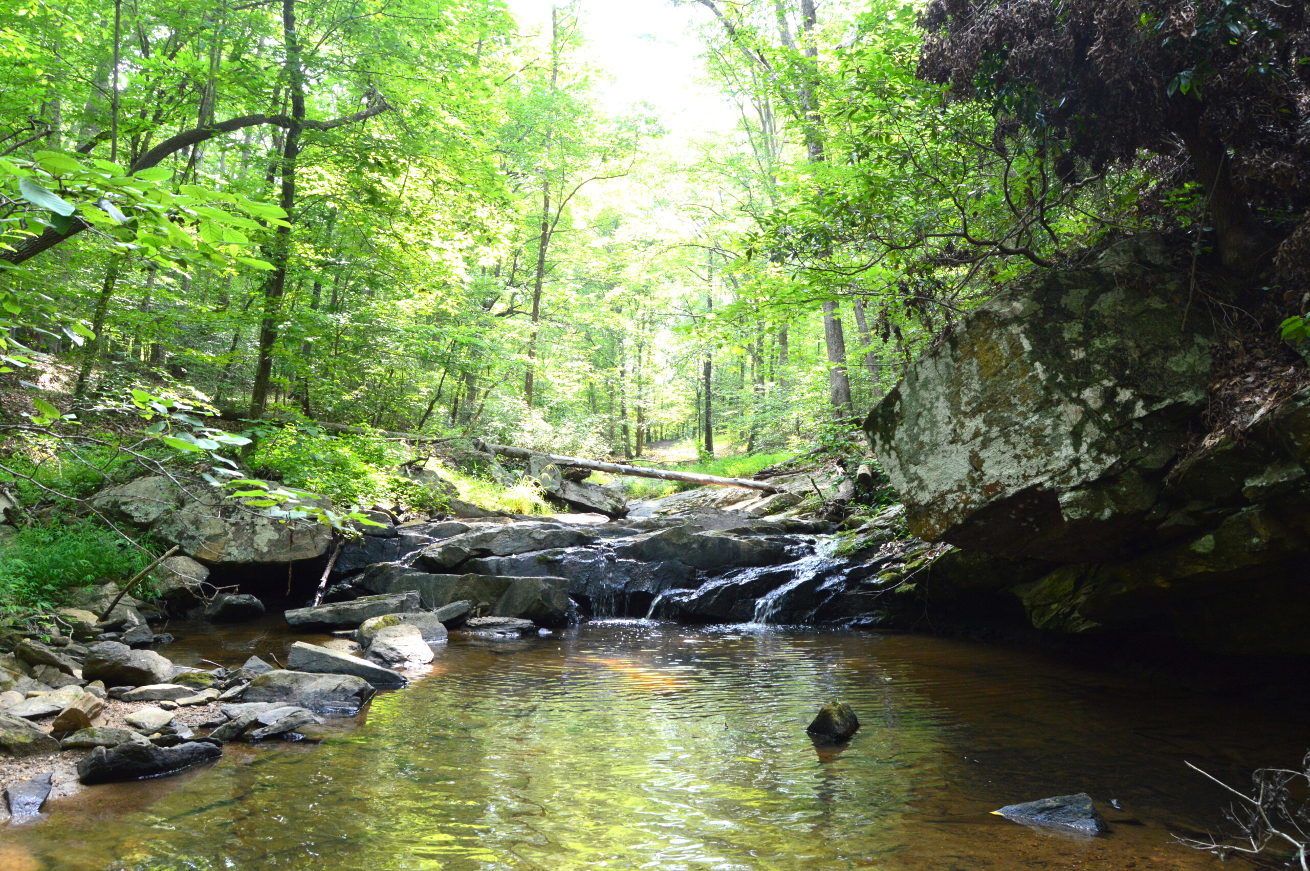
Coming to the market for the first time is a 112-acre generational farm located in northeastern Rockingham County NC that falls in the highly sought-after <em>“Trophy Belt of NC”</em>. The Quesinberry Farm offers a blank canvas for a Buyer looking to develop a premium recreational property or take it back to its former glory as an active cattle farm.
The farm is compiled of a well-balanced mix of active and reclaimable pastureland that encompasses approximately 30% of the property. These areas are mainly along high contours and run from the center of the tract down into the most southern section with additional terrain to expand. The open land would make ideal wildlife food plots with natural funnels running along the field pockets and creating excellent hunting opportunities. The remainder of the property has diverse timber stands with some smaller pockets along the southern sections being previously cut and the northern sections of the property are more mature. There is a good balance of Oak, Poplar, and Maple throughout the property.
Running along the southern border is a larger stream known as Machine Creek which offers some exceptional views of rock ledges and waterfalls. Additionally, there are several small spring originated streams in the interior of the property offering several ideal pond locations that would add additional value to the farm.
This is a well-balanced property with good diversification and sits conveniently located just outside of Eden NC.
<em><strong>The Facts</strong></em>
<ul>
<li>Opening Bid amount $250,000</li>
<li>Bidding Opens 10/1/24 @ 12pm</li>
<li>Bidding Close 10/15/24 @ 12pm</li>
<li>112.15 +/- acres</li>
<li>Approx. 960' of frontage on Town Creek Rd</li>
<li>Approx. 1450' of frontage on Quesinberry Rd</li>
<li>Gas line easement cutting through northeast corner</li>
<li>Boundary stream on southern boundary "Machine Creek"</li>
<li>Multiple trails</li>
<li>Mixed timber</li>
<li>Excellent wildlife habitat</li>
<li>39+/- acres of previous pasture land / reclaimable</li>
<li>Currently in AG / Forestry tax deferment</li>
</ul>
<em><strong>Location</strong></em>
<ul>
<li style="list-style-type: none;">
<ul>
<li>4 miles east of Eden NC</li>
<li>9 miles north of Reidsville NC</li>
<li>15 miles north of Burlington NC</li>
<li>30 mikes north of Greensboro NC</li>
<li>76 miles northwest of Raleigh NC</li>
<li>5 miles south of Virginia</li>
</ul>
</li>
</ul>
[maxbutton id="1" url="https://clearwatergroupofnc.hibid.com/lot/206194593/quesinberry-rd---112-15-----acres" text="GO TO AUCTION" ]
[maxbutton id="1" url="https://www.dropbox.com/scl/fo/ato67xvrqgio6nq0vyfkh/AO_jljLYtTcE_Hdxo2E39xY?rlkey=bwm6h4anur3xumfzkpb5rbhmd&st=u62a1yck&dl=0" text="BIDDER PACKET" ]
<div style="padding: 56.25% 0 0 0; position: relative;"><iframe style="position: absolute; top: 0; left: 0; width: 100%; height: 100%;" title="112 +/- ACRE QUESINBERRY TRACT" src="https://player.vimeo.com/video/985164941?badge=0&autopause=0&player_id=0&app_id=58479" frameborder="0"></iframe></div>
<iframe src="https://id.land/maps/3e2a0b97929f72c165124943072c8a4f/embed" width="1375px" height="520px" frameborder="0"><span data-mce-type="bookmark" style="display: inline-block; width: 0px; overflow: hidden; line-height: 0;" class="mce_SELRES_start"></span><span data-mce-type="bookmark" style="display: inline-block; width: 0px; overflow: hidden; line-height: 0;" class="mce_SELRES_start"></span></iframe>;
<strong>THE REAL PROPERTY IS BEING OFFERED TO THE PUBLIC THROUGH ONLINE BIDDING ONLY. </strong><strong>PLEASE READ ALL TERMS OF THE SALE CAREFULLY PRIOR TO REGISTERING AND BIDDING. REGISTERING TO BID CONFIRMS THAT YOU HAVE REVIEWED AND AGREE TO THE FOLLOWING TERMS.</strong>
<ul>
<li style="list-style-type: none;">
<ul>
<li><strong>AS IS</strong>: The REAL PROPERTY and all improvements, if any, will be sold AS-IS with no representations or warranties, expressed or implied. Bidders are encouraged to conduct their inspections and due diligence prior to bidding at the auction. All information provided is believed to be correct but is not guaranteed.</li>
<li><strong>RIGHT OF WAYS, EASEMENTS, & COVENANTS:</strong> THE REAL PROPERTY is being sold subject to any or all RIGHT OR WAYS, EASEMENTS, AND COVENANTS. Bidder is responsible for doing their own property investigations prior to bidding on the property.</li>
<li><strong>PROPERTY RIGHTS</strong>: Mineral rights, timber rights, water rights, if any, will transfer with REAL PROPERTY unless otherwise disclosed.</li>
<li><strong>PROPERTY PREVIEW: </strong>Scheduled preview dates will be announced prior to auction start date or Bidders may also request a preview of the property through scheduled appointments. All previews of the property shall be through appointment only.</li>
<li><strong>PRE-AUCTION OFFERS: </strong>Seller reserves the right to accept or reject any offers properly presented prior to the start of the auction bid period. All offers submitted prior to the start of the auction bid period are subject to the same auction terms such as due diligence deposit, buyer’s premium, and no contingencies. If an offer is accepted prior to the start of the auction bid period any registered bidders will be notified, but the contract price will remain confidential.</li>
<li><strong>REGISTRATION:</strong> Registration is required for online bidding in advance and is the sole responsibility of the bidder to confirm they are registered prior to the auction start time.</li>
<li><strong>BIDS AND INCREMENTS:</strong> Auction Firm has the sole discretion to determine the highest bidder and to set bid increments.</li>
<li><strong>QUALIFIED BIDDERS:</strong> Auction Firm reserves the right to refuse to register or remove any bidder from the site for any reason and request additional information from any bidder.</li>
<li><strong>SOFT CLOSE:</strong> The online bidding is a timed event. Auction Firm reserves the right to extend the auction in 2-minute segments for all bids received in the last 2 minutes of the auction.</li>
<li><strong>SELLER CONFIRMATION: </strong>The REAL PROPERTY is being offered for an online auction only; bids will be subject to approval of the Seller.</li>
<li><strong>METHOD OF SALE:</strong> If Seller accepts the highest bid, the high bidder will be notified by 5pm on the end day of the auction. The bidder will have 24 hours to execute an NC Offer to Purchase Contract and other required documents upon notification of the winning bid. Winning bids may not be assigned except to entities that the bidder owns the majority interest in.</li>
<li><strong>AGENCY:</strong> Buyer will be required to sign an agency disclosure form stating that the buyer is aware that the <strong>Clearwater Group of NC INC</strong>. represents the seller and the seller’s interest in the transaction.</li>
<li><strong>QUALIFICATION:</strong> The Auction firm reserves the right to request pre-qualification prior to accepting registration from any bidders.</li>
<li><strong>PURCHASE CONTRACT:</strong> Within 24 hours of the close of the auction, Buyer will be required to submit their deposit and execute the most recent NC Offer to Purchase Contract 2T or Vacant Land Offer to Purchase; whichever is applicable to the type of property being sold.</li>
<li><strong>NO CONTINGENCIES: </strong>The offer to purchase contract is not subject to any buyer contingencies for financing, appraisal, surveys, inspections, soil testing, or any other contingencies.</li>
<li><strong>DUE DILIGENECE DEPOSIT</strong>: 2% of the sales price will be required in the form of a due diligence deposit <em>(non-refundable)</em> no less than 24 hours from the close of the auction, and the balance of the purchase price will be due at closing. The due diligence deposit will be credited back to the buyer at closing.</li>
<li><strong>BUYER’S PREMIUM: </strong>Buyer will be required to sign a buyer’s premium agreement upon execution of the offer to purchase contract. A buyer’s premium of 8% is added to the last and highest bid to determine the contract purchase price. EXAMPLE – if the high bid is $100,000.00, a buyer’s premium of $8000 is added and the purchase price would be $108,000.00.</li>
<li><strong>CLOSING: </strong>Closing is to take place no more than <strong>45</strong><strong> days</strong> from the close of the auction; TIME IS OF THE ESSENCE.</li>
<li><strong>POSSESSION:</strong> Possession will be given at closing, subject to existing leases, IF ANY.</li>
<li><strong>BUYER DEFAULT:</strong> TIME IS OF THE ESSENCE with regards to the Closing Date. Buyer shall forfeit the deposit if Buyer fails to close on or before the Settlement Date as set forth in the Offer to Purchase.</li>
<li><strong>TECHNICAL PROBLEMS</strong>: The Auction Firm will not be liable for any faulty equipment, failure of equipment, faulty software, failure of software, lack of internet service connections or signals, or failure for any online bids that are not relayed on time to the Auction Firm. The Auction Firm reserves the right to extend bidding, delay bidding, or cancel bidding, without any notice to online bidders.</li>
<li><strong>DISCLAIMER:</strong> The Auction Firm provides property information that is believed to be accurate, but it is not guaranteed. Bidders must do their own due diligence prior to bidding on the property. By bidding on the property buyers acknowledge that they are satisfied with the property and agree to purchase AS IS.</li>
<li><strong>ADDITIONAL TERMS AND CONDITIONS</strong>: The Buyer agrees that if they do not wish to assume the current deferment status at closing, they will be responsible for any roll back taxes at closing.</li>
</ul>
</li>
</ul>
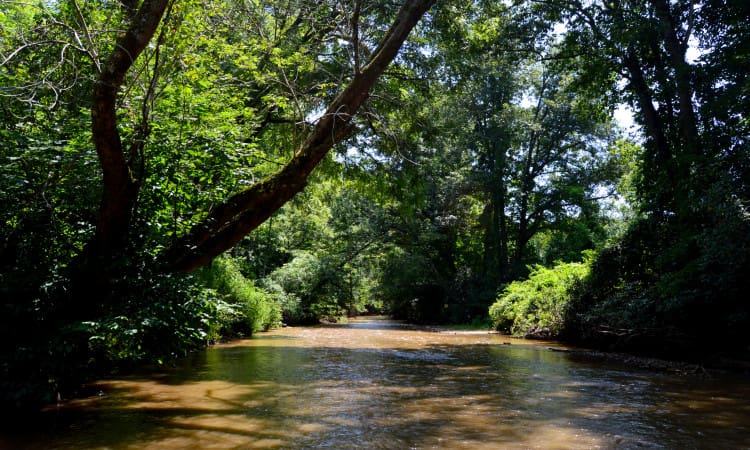
Located in the heart of the Yadkin Valley is a one of a kind 307+/- acre generational farm that rest along the eastern banks of the Mitchell River. This property has been cherished by the same family for many years and is now being offered for the next owners to enjoy. Located just west of I-77 in the Elkin community and falling just south of the old Kapps Mill that rest along the Mitchell River banks just north of the property.
When entering the property off Kapps Mill rd on the northeastern corner you are greeted by small gravel drive known as Newbern Ln which leads through the interior of the property giving all weather access. Along the winding drive you encounter a diverse landscape of rolling foothills topography and towering timber. Leading off of Newbern Ln are a multitude of atv or walking trails that all lead to interesting areas of the property.
Along the eastern section of the property you find topography that has a moderate slope down to a beautiful mountain stream that is lined with towering laurel and rhododendron. As you approach this area you are taken back with the drop in the temperature along the shaded creek banks. This area feels like its own little world with the sounds of the stream splashing over the rock ledges and falling into small pools, all while being sheltered under the rhododendron canopies.
If you head west off of Newbern Ln this section of the property shares a totally different environment which is mainly large timber and a towering canopy with a park like setting. Throughout most of the property you can find abundant sign of wildlife, furthermore showing that the habitat is adequate and supportive. Upon touring the property there was abundant evidence of turkey roosting and scratching, also a great deal of whitetail sign.
Huckleberry Hill has a tremendous amount of natural resources, but by far the most valuable is the vast frontage along the Mitchell River. The property holds an array of recreational benefit for the conservation minded owner and the Mitchell River is one of the State of NC's top trout fishing rivers with a tremendous amount of natural beauty. Additionally, the area also is surrounded by like minded owners who cherish the area and the River's benefits.
<em><strong> Virtual Tour</strong></em>
<iframe title="YouTube video player" src="https://www.youtube.com/embed/EfNs6hwGUzI" width="1300" height="520" frameborder="0" allowfullscreen="allowfullscreen"><span style="display: inline-block; width: 0px; overflow: hidden; line-height: 0;" data-mce-type="bookmark" class="mce_SELRES_start"></span><span style="display: inline-block; width: 0px; overflow: hidden; line-height: 0;" data-mce-type="bookmark" class="mce_SELRES_start"></span></iframe>
<em><strong>Interactive Map</strong></em>
<iframe src="https://mapright.com/ranching/maps/05329500749345d6ee8b4091ad1f3e95/embed" width="1300px" height="520px" frameborder="0"></iframe>
<strong>The Facts</strong>
<ul>
<li>1985 survey (PB 30 / PG 186-7) shows 311+/- acres</li>
<li>60+/- acres of timber harvested in 2014 (northeastern corner)</li>
<li>275 +/- acres of mature timber (white pine, poplar, chestnut/white/red oak)</li>
<li>3120' +/- of frontage along the Mitchell River - <em>https://www.planetware.com/north-carolina/top-rated-rivers-for-trout-fishing-in-north-carolina-us-nc-51.htm</em></li>
<li>6,600' +/- of stream located on the property</li>
<li>Internal Road "Newbern LN" - 45' R/W agreement</li>
<li>2784' +/- frontage along Kapps Mill Rd</li>
<li>Gated entrance along Newbern LN</li>
<li>Existing hunting lease runs until Jan. 1 2022</li>
<li>Property is in "PUV" status</li>
<li>2021 deferred tax bill - $433.76</li>
<li>.7 mile down stream from the Mitchell River House - setting used in the Nicholas Sparks movie, <em>"The Longest Ride"</em></li>
<li>10 miles north of Elkin - <em>http://www.elkinnc.org/</em></li>
<li>2.4 miles south of the Mitchell River Game Land</li>
<li>2.5 miles west of I-77</li>
<li>20 miles north of Yadkinville</li>
<li>38 miles northwest of Winston Salem</li>
<li>Will not subdivide</li>
</ul>
This is a great opportunity for 138+/- acres located in southwest Surry County. The property is located just west of Hwy 52 right off of Hwy 268 and just north of Yadkin County, located at the end of Walker Rd with a gated entrance and has an established roadway/trail system throughout.
The timber on majority of this tract was harvested in late 1997 and has naturally regenerated with a good mix of Poplar, Oaks, and VA Pine. Additionally there is a small grouping of planted White Pine on the northern section that measures 13"- 18" on average.
The property is a great mix of natural wildlife habitat with rolling topography and diversity. The riparian buffers left from the previous harvest has created excellent north/south funnel corridors and are currently being heavily traveled. Additionally the property has two established sizeable food plots.
<em><strong>The Facts</strong></em>
<ul>
<li>138.37 +/- acres per tax records (no recent survey)</li>
<li>Mixed timber - previously harvested in 1997</li>
<li>Established trail system throughout</li>
<li>Several small streams and springs on the property</li>
<li>Two established food plots</li>
<li>Power line easement running east to west through the center of the property</li>
<li>45' joint easement at the entrance (see attachments)</li>
<li>Farm Rd easement noted on deed to service neighboring tract to the east (see attachments)</li>
</ul>
<em><strong>Interactive Map</strong></em>
<iframe src="https://mapright.com/ranching/maps/e3d798658fe30d90bb3e65655bf239ec/embed" width="1300px" height="520px" frameborder="0"></iframe>