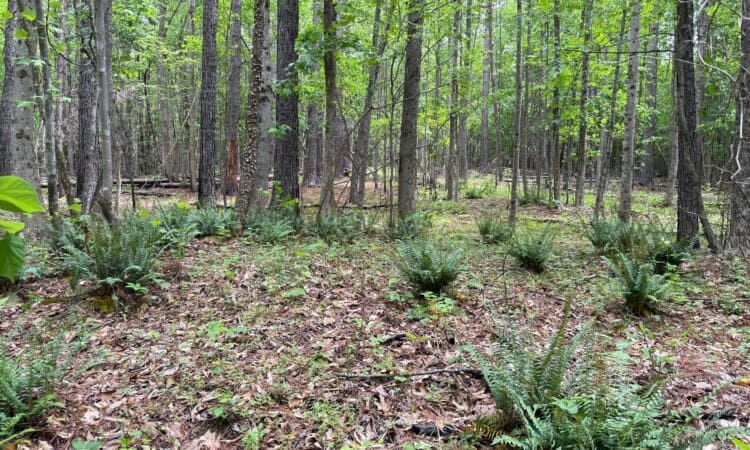
Situated in the Bethany community of Rockingham county you'll find this very nice 31.5+/- acre tract of land. There are currently two established entry points along the 1000+ feet of road frontage along Purcell rd. One trail leads back to a beautiful and private section of woods where soil testing has been completed and suitable building sites have been found. The other trail systems goes through the lower section of the property that was previously 5+ acres of tillable fields. Trees have grown up since then creating a great hunting habitat but the fields could be re-claimed with a little work. The topography of most of this tract is very good and it offers exceptional privacy and the potential for several home sites. Multiple streams create opportunities for creating your own pond and really making this property a masterpiece. There is an abundance of deer and turkey showing the potential for exceptional hunting. A full boundary survey is in progress so the final acreage will be available at it's completion. No Trespassing. Shown by appointment only.
<iframe src="https://id.land/maps/a762694d3bdf84bda91450f1aaafa3a9/embed/unbranded" width="1250px" height="520px" frameborder="0"></iframe>
<em><strong>The Facts</strong></em>
<ul>
<li>31.5 +/- Acres currently being surveyed</li>
<li>Multiple creeks</li>
<li>1000'+ road frontage on State maintained Purcell rd</li>
<li>Zoning RA</li>
<li>Preliminary Soil testing complete</li>
<li>Mixed timber</li>
<li>Excellent wildlife habitat</li>
<li>Multiple Building sites</li>
<li>Bethany Elementary, County Schools</li>
</ul>
<em><strong>Location</strong></em>
<ul>
<li>Located in Reidsville NC</li>
<li>22 miles Southwest of Danville VA</li>
<li>10 Miles North of Greensboro NC</li>
<li>23 miles northeast of Burlington NC</li>
<li>65 miles northwest of Raleigh NC</li>
</ul>
Located in Danbury, just minutes from Hanging Rock State Park you'll find these two surveyed parcels that have been combined to create 46.9 unrestricted acres. Recent soil testing has confirmed multiple building sites near the road that offer incredible long range view and are already partially cleared. Should you wish for more privacy there are multiple other sites at higher elevations that could offer exceptional views. This land is ideal for somebody that is willing to put in the work to establish the necessary hiking and ATV/UTV trails to be able to fully enjoy this land. The eastern border offers a buffer of mature timber while the rest of the property has natural hardwood regeneration that appears to be 10-15 years old. This has all of the wildlife signs of an excellent hunting property and could be improved greatly with the addition of food plots. Multiple springs and small streams lead to a larger creek that offers beautiful rock formations. All mineral oil and gas rights convey! This land is a blank slate that is waiting for it's new owner to make it their own.
<em><strong>The Facts</strong></em>
<ul>
<li>Two surveyed tracts totaling 46.9 acres</li>
<li>1000+ feet of road frontage along Seven Island Rd</li>
<li>Beautiful internal creek</li>
<li>Rolling Topography</li>
<li>Zoning R-A</li>
<li>Suitable soil locations for septic systems</li>
<li>Mixed timber</li>
</ul>
<em><strong>Location</strong></em>
<ul>
<li style="list-style-type: none;">
<ul>
<li>Located in Danbury NC</li>
<li>2 miles northeast of Hanging Rock State Park</li>
<li>24 miles north of Winston Salem NC</li>
<li>36 miles northwest of Greensboro NC</li>
<li>16 miles east of Pilot Mountain NC</li>
<li>100 miles west of Raleigh NC</li>
</ul>
</li>
</ul>
<iframe src="https://id.land/maps/6d81b69a3b3ca5acd7ae0c0a2b7341f1/embed" width="800px" height="520px" frameborder="0"></iframe>
Located just outside of the Eden City Limits and within the Rockingham County School district is this unique 10.1-acre tract with an abundance of seclusion and natural beauty. The property is situated just south of the Harrington Hwy / Hwy 87 intersection and offers a recent survey, cleared access, and potential homesite. Compiled of mature majestic timber, rolling topography, and a small stream the property offers a park-like feel with an abundance of privacy coupled with a very convenient location. Public utilities are located at the entrance of the property along Peppermill trail.
<em><strong>The Facts</strong></em>
<ul>
<li>10.174 +/- surveyed acres</li>
<li>Rolling topography</li>
<li>Convenient location just outside of Eden</li>
<li>Public utilities located at the property entrance</li>
<li>Mature timber</li>
<li>Cleared access and potential homesite</li>
<li>Zoned R12ED</li>
<li>Restrictions will apply - (see attachments)</li>
</ul>
<em><strong>Location</strong></em>
<ul>
<li>2 miles southwest of Eden NC</li>
<li>6 miles south of VA state line</li>
<li>1o miles north of Reidsville NC / Hwy 29</li>
<li>27 miles north of Greensboro NC</li>
<li>36 miles northeast of Winston Salem NC</li>
</ul>
<iframe src="https://id.land/maps/f258ca7b6aa08a18c88ce79b93e13148/embed" width="1350px" height="520px" frameborder="0"><span data-mce-type="bookmark" style="display: inline-block; width: 0px; overflow: hidden; line-height: 0;" class="mce_SELRES_start"></span><span data-mce-type="bookmark" style="display: inline-block; width: 0px; overflow: hidden; line-height: 0;" class="mce_SELRES_start"></span></iframe>
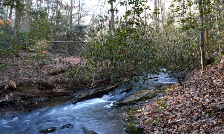
Secluded 70± Acre Recreational Paradise in Danbury, NC – Featuring Private Lake, Waterfall, and River Access
Nestled just off Hwy 8–89 in the scenic area of Danbury, NC, this remarkable 70± acre tract offers an extraordinary combination of privacy, natural beauty, and recreational potential. Hidden from sight, the property is a rare find with features that make it truly one-of-a-kind.
At the southeastern entrance, a winding trail leads you below the mature hardwood forest to the mouth of the historic Stedman Lake—a privately held 5± acre lake originally constructed in the 1930s by the Isaac Walton League. Tucked away and surrounded by hardwood bluffs, the lake is a peaceful sanctuary offering stunning views and several ideal building sites for a secluded cabin or lodge. From the lake, a bold stream spills over a dramatic 30-foot concrete dam, creating a breathtaking waterfall. The cascading water continues through natural rock ledges and eventually flows into the nearby Dan River, adding to the property’s already impressive list of natural amenities.
Whether you're envisioning a private retreat, a legacy recreational property, or a haven for outdoor adventure, this tract offers unmatched potential in one of North Carolina’s most beautiful and historic areas.
<div style="padding: 56.25% 0 0 0; position: relative;"><iframe style="position: absolute; top: 0; left: 0; width: 100%; height: 100%;" title="Stedman Lake - 70 AC Tract" src="https://player.vimeo.com/video/1082259827?badge=0&autopause=0&player_id=0&app_id=58479" frameborder="0"></iframe></div>
<script src="https://player.vimeo.com/api/player.js"></script>
<iframe src="https://id.land/maps/bea973707bd7a3218e599e007fdac6e5/embed" width="1350px" height="520px" frameborder="0"><span data-mce-type="bookmark" style="display: inline-block; width: 0px; overflow: hidden; line-height: 0;" class="mce_SELRES_start"></span></iframe>
<em><strong>The Facts</strong></em>
<ul>
<li>70 +/- acres subject to survey</li>
<li>380' +/- frontage on the Dan River</li>
<li>Privately held 5+/- acre Stedman Lake</li>
<li>1000'+/- frontage on Hwy 8 / 89</li>
<li>Zoning R-3</li>
<li>Public water and sewer accessible</li>
<li>Mature timber</li>
<li>Elevations from 750' to 830'</li>
<li>Bold stream</li>
<li>Multiple homesites</li>
</ul>
<em><strong>Location</strong></em>
<ul>
<li>Located in Danbury NC</li>
<li>.6 miles north of Hanging Rock State Park</li>
<li>22 miles north of Winston Salem NC</li>
<li>35 miles northwest of Greensboro NC</li>
<li>15 miles east of Pilot Mountain NC</li>
<li>100 miles west of Raleigh NC</li>
</ul>
This is a great opportunity for 138+/- acres located in southwest Surry County. The property is located just west of Hwy 52 right off of Hwy 268 and just north of Yadkin County, located at the end of Walker Rd with a gated entrance and has an established roadway/trail system throughout.
The timber on majority of this tract was harvested in late 1997 and has naturally regenerated with a good mix of Poplar, Oaks, and VA Pine. Additionally there is a small grouping of planted White Pine on the northern section that measures 13"- 18" on average.
The property is a great mix of natural wildlife habitat with rolling topography and diversity. The riparian buffers left from the previous harvest has created excellent north/south funnel corridors and are currently being heavily traveled. Additionally the property has two established sizeable food plots.
<em><strong>The Facts</strong></em>
<ul>
<li>138.37 +/- acres per tax records (no recent survey)</li>
<li>Mixed timber - previously harvested in 1997</li>
<li>Established trail system throughout</li>
<li>Several small streams and springs on the property</li>
<li>Two established food plots</li>
<li>Power line easement running east to west through the center of the property</li>
<li>45' joint easement at the entrance (see attachments)</li>
<li>Farm Rd easement noted on deed to service neighboring tract to the east (see attachments)</li>
</ul>
<em><strong>Interactive Map</strong></em>